


Imagine playing your favorite city-building computer game, creating bustling busy streets and a whole collection of different buildings in order to create a successful metropolis. Power plants provide electricity for the town, roads connect everything together, and people complete their own individual tasks that contribute to the economic growth of the city, or you could say the “health” of the city. You also create scenarios and essentially run simulations of differing conditions in this city of yours. Now, imagine a similar computer game, except this time the topic is not so familiar: creating a river ecosystem. The similarities to computer games are the fundamentals (and fun) behind the field of Ecological Modeling, which is essentially about being able to manipulate whole ecosystems with the click of a mouse.
To help measure the components of an ecosystem, it is worth constructing a computer simulation model of the area. If you take the Mississippi River as an example, it is impossible to conduct a study along a small part of the Mississippi, let alone the entire river. Questions such as, “How big does my study area need to be in order to be informative, and can I manipulate an area this large?” are often asked in Ecology. Usually the answer is no, either due to legal objections (e.g. don’t burn down this forest for an experiment) or due to other factors such as money and manpower. Can you really sample a forest quickly enough to uncover rapidly occurring processes?
Models can manipulate whole Ecosystem components with a click of a button. This gives us great flexibility and power when investigating processes that effect whole ecosystems and can potentially save lots of money. RiverModel is one such example of a model encompassing an area along the Mississippi River near La Crosse, WI. This area, also called a pool, is the body of water between two locks and dams that the Upper Mississippi River is famous for, or infamous depending on whom you talk to. The study area for RiverModel is Pool 8, which is nearly 22,000 acres of river habitat. Using this model will make it possible to manipulate many of the factors that are important to the river ecosystem such as river sediments, sunlight levels, and temperatures across the whole pool. RiverModel allows river managers to investigate the effects of changes in these factors in a matter of hours from the comfort of their office with virtually no cost.
Damming effects on the Mississippi River
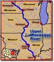 The Mississippi River is divided into two sections known simply as the Lower and Upper sections. The point that splits the mighty river in two is the quiet town of Cairo, IL. North of the split, in Minnesota, you have the lively headwaters, i.e. the origin of a river, that rush towards the sea carving out a name for itself on the landscape. The headwater gradually becomes calmer until it widens and becomes the mighty Mississippi we all know it for here in Illinois. The lower portion is the calmer section that elegantly meanders its way across the landscape towards the sea. The western border of Illinois is made up of 550 miles of the Upper Mississippi River. This area is known for its dams that serve a primarily navigational purpose. However, some argue that these dams are detrimental to the Mississippi by disrupting the natural flooding cycle of the river and disrupting the connection along the river’s length. The dams have had positive effects on fish populations by creating slow moving water suitable for aquatic plant growth that, in turn, provides food and shelter for them.
 Most of the areas in the Upper Mississippi River have a calm and slow flow due to the dams and are densely populated with aquatic vegetation (e.g. Macrophytes). According to who you talk to, there are anywhere between 100 to 120 species of fish in the Mississippi River. In fact, the Mississippi is the cleanest and healthiest river in the temperate latitudes. Not only is the Mississippi full of fish, but it is also home to some rather impressive birdlife. According to a USGS report, the Mississippi River is a migration route for forty percent of North America’s waterfowl and shorebirds. It also provides habitat to birds such as canvasback ducks (fifty percent of the whole world’s population!) and bald eagles that have over 250 nests according to recent surveys by the U.S. Fish and Wildlife Service along the Mississippi River. Additionally, the river also provides a resource that all of us use every day … water! It is estimated by the Army Corps of Engineers that anywhere between fifteen and eighteen million people and fifty cities depend on the Mississippi River for their everyday water supply.
Managers, Rivers and Watersheds
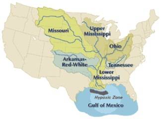
This huge river, some 2,300 miles long, clearly requires a lot of work from many different parties to manage. The scale of their problem gets even bigger when you start talking about things like the watershed of the Mississippi River. A watershed is the drainage area of an entire river. If you were to pour a drop of water onto the ground, which body of water would it end up in? The Mississippi’s watershed stretches from the Rockies in the west to the Allegheny Mountains in the east. It covers all or some parts of thirty-one states and two Canadian provinces. Here in Champaign-Urbana, we live in the watershed of the Mississippi. This means that actions we all take will eventually have an effect on the Mississippi River. For example, if someone in Champaign-Urbana were to dump chemicals into a storm drain, those chemicals would eventually make their way into the Mississippi River. Clearly it is a huge task to manage an area of this size (1.2 million square miles) or 40 percent of the lower 48 states. How much of this area should be managed, and more importantly, how much of this area can be managed? Models and rivers, what’s this all about then?
Well now you may be wondering how all these factoids relate to the model that I mentioned at the beginning of this article. RiverModel measures the flow of carbon between ten different stocks in the river, including fish and aquatic plants. We measure carbon because all living things are made of carbon, and it provides a convenient, consistent method when investigating the relationships among many different types of organisms. That is to say, it is a standard measure among plants, animals, and microorganisms.
 This model will be used by managers to investigate the results of actions they take along the river. For example, if a manager wants to increase the amount of Canvasback ducks, a popular game duck, arriving at their section of the river one season, then he or she will want to increase the amount of aquatic plants that grow in the river, which are food sources for the ducks. RiverModel is used to simulate the river under varying conditions allowing the results of management actions to be predicted in a sense. This ensures that the action that has the best and most desired effect on the aquatic plants in the river can be implemented. This will then attract more Canvasback ducks, increasing revenues of the river due to increases in hunting licenses, park admissions, and so forth.
RiverModel also will provide a very powerful tool to managers across the whole river and not just Pool 8 (the area RiverModel is simulating), as this model can be applied to any area of the river that has the correct data, including factors such as water flow and temperature. This means that a manager in New Orleans can perform the same simulations and come to similar conclusions about his portion of the river as someone in Illinois can.
This is a big river!
People who work on the river have told me that there is a certain frustration working on something that changes so often. The river constantly flows ever towards the sea; fish and birds move freely, meaning researches find it difficult to perform experiments on the river. This makes it difficult to measure the effects of experiments on populations in the river, and one can only often implement the management activity and hope it is the best course. With RiverModel, the goal is to take away some of this uncertainty and have managerial actions be based on somewhat informed decisions.
For example, in Pool 8 there has been an island construction project ongoing for about twenty years. The main goal behind this was to increase sheltered habitat for fish spawning in and around these islands, with a secondary objective of increasing canopy cover along the pool by planting trees on these islands. Fish populations are measured continuously every year, and so far, between now and the time that the islands were built, there doesn’t seem to be the desired increase in their populations. This highlights the need for some sort of predictive tool to shape management plans along the river to increase efficiency and maximize available management resources.
The Mississippi is certainly a complex entity definitely deserving of the adjective “mighty!” It requires enormous effort by many hundreds to thousands of individuals for us to enjoy every day. I hope that by creating a tool such as RiverModel, I’ve made their jobs a little bit easier!
Article written by Kevin Freeney, Ph.D. student in Ecology, Evolution, and Conservation Ecology
~~*~~
Smile Politely is proud to introduce a new running series we are calling “Science Politely” that will feature the work of graduate students at the University of Illinois throughout November and December. Working in collaboration with the students in a graduate course in Integrative Biology, Science Politely is a collaboration aimed at bridging the gap between town and university, between scientist and citizen, and between research and culture.