


Issues pertaining to the water supply in East Central Illinois have been much in the news over the past year. Objections to PCBs possibly being stored at Clinton Landfill continue. The Village of Homer has now agreed to provide water to Sunrise Coal LLC for their proposed coal mine. And of course we had a drought last summer. To get a local expert’s perspectives and opinions on these topics and more, I spoke recently with Andrew Stumpf, a geologist at the Illinois State Geological Survey (ISGS), a division of the Prairie Research Institute at the University of Illinois at Urbana-Champaign.
Storing PCBs at Clinton Landfill
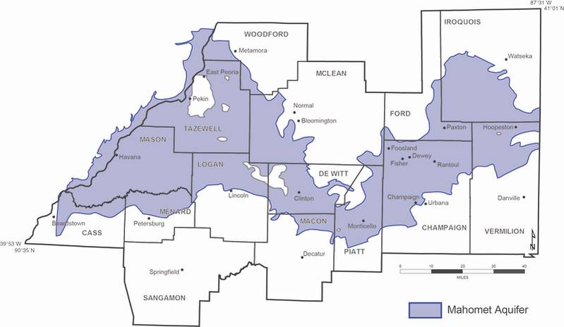
Clinton Landfill officials have said that the PCBs they want to dispose of at Clinton Landfill would be stored over clay and also wrapped in liners; therefore there wouldn’t be any danger of them getting into the Mahomet Aquifer — at least not for a long time. I asked Stumpf how true that is. He responded:
I don’t have a basis to comment on the integrity of the landfill that is proposed for long-term storage of PCBs. However, engineers have done significant research in designing landfills so that waste can be stored safely for many years, but perhaps not indefinitely. But two of the questions many people have asked are, why take the risk of disposing PCBs at a site that is located over the Mahomet Aquifer? Aren’t there places not over the aquifer that could be suitable for waste disposal? These are valid questions that could be addressed as part of the process for determining land use.
So why would Clinton Landfill officials even consider storing PCBs above the aquifer in the first place? Stumpf said that there’s a pretty simple reason: “Most likely, because there is already a landfill at that location.”
I asked Stumpf his opinion on how effective obtaining a Sole Source Aquifer (SSA) designation from the U.S. EPA, which the cities of Champaign, Urbana, and other groups are attempting to do, would be in stopping PCBs being stored at Clinton Landfill.
My understanding is the SSA would not directly impact expansion of the Clinton Landfill. Under the SSA designation, U.S. EPA is only required to review and approve projects that receive federal financial assistance, including highway improvements and new road construction, public water supply wells and transmission lines, wastewater treatment facilities, construction projects that involve management of stormwater, agricultural projects that involve management of animal waste, and projects funded through Community Development Block Grants.
The expansion of the Clinton Landfill, I believe, is being paid for with private funds. But some governments, such as the States of Illinois, Washington, and Ohio, have adopted their own laws and regulations in addition to the federal law for municipal landfills and dangerous waste management facilities proposed over SSAs. I don’t have a basis to comment whether the Illinois statutes would be applied to the expansion of an existing landfill. For residents of East Central Illinois, one of the greatest values of this SSA effort might be to increase the public awareness of groundwater issues.
Other issues with the Mahomet Aquifer
I asked Stumpf if there were other potential threats of pollution to the Mahomet Aquifer aside from PCBs being stored at Clinton Landfill. He replied,
Yes there could be. Any borings that were not, or are not, properly sealed and improperly constructed water, oil, and gas wells could potentially be avenues of contamination to the Mahomet Aquifer and the other overlying aquifers. They need to be properly closed and plugged. Also, there are other waste disposal sites located over these aquifers, some that were used before standards for permitting landfill design and monitoring of environmental impacts were required or implemented.
Aside from water pollution, I asked Stumpf if the residents of East Central Illinois need to worry about having enough water over the next 100 years or so, in general. He said:
Scientists have completed studies to predict water usage in East Central Illinois over the next fifty years or so. We know how much groundwater is currently being withdrawn and can use that information to predict future water demand under various usage scenarios. But I think we are less confident about how much water is available from the Mahomet Aquifer and the other overlying aquifers. We still haven’t been able to identify and study all the complexities of the groundwater flow system, including from the point water reaches the water table to where it flows out into streams or pumped from a well. Further studies are required to more fully understand how these aquifers are being recharged. This information would be necessary to develop more accurate water budgets.
Why did wells in the Fisher-Dewey area run dry last summer?
There was a recent story in The New-Gazette about some people living in the countryside in the Dewey-Foosland-Fisher area whose personal wells ran dry last summer. Some blamed a nearby well drilled for irrigation. Stumpf gave his thoughts on the situation:
This was a rather unfortunate situation! I don’t know where all the affected wells are located in respect to the irrigation well, but there are a number of other factors besides the weather and irrigation pumpage that could have played a part in the wells going dry. The construction and maintenance of the wells, depth of the pump in respect to the water level, and a general increase in pumpage over the summer months by residents in the area, independently or collectively, may have contributed to the decline of water levels in some wells.
Water resource experts recommend that water wells be properly designed and maintained to help lessen the effects of drought on the water level in wells. In some cases, lowering the pump in the well may alleviate the impacts of seasonal fluctuation of the water level. For homeowners interested in learning more about their water wells, the Illinois State Water Survey (ISWS) and Illinois Water Resources Center at the University of Illinois at Urbana-Champaign, under contract with Rural Community Assistance Partnership, are offering a free online service, “Private Well Class,” which is scheduled to take place in late March, April, and May. This class will help educate homeowners on how to properly care for their water well, to ensure their water remains safe to drink.
From a scientific perspective, I think we really need to do more study in this area of the county because the geology of the Mahomet Aquifer is more complex here than in other areas of East Central Illinois. The area affected is very close to the edge of the Mahomet Aquifer as currently mapped. Also, in parts of this area, the deposits of sand and gravel composing the Mahomet Aquifer are separated by layers of clay-rich sediment. We don’t fully understand how this interlayering affects groundwater flow and the relationships between the Mahomet Aquifer and those layers overlying it.
There is little doubt that the drought was an important factor leading to a decline in water levels in wells this past summer. To better understand and help alleviate these affects, the ISGS, the ISWS, and the United States Geological Survey (USGS) have partnered together to continually record the water levels in East Central Illinois in some wells that are screened in the Mahomet Aquifer and the overlying aquifers, and at the water table. The data collected are being used to help identify and track impacts on the aquifers. At one of these monitoring sites, located southwest of the Village of Fisher, the data (provided through the USGS Groundwater Watch) show that water levels in all four monitoring wells at the site (wells 17–20 on the index map) dropped by 3 to 8 feet between May and August 2012. Although, we expect the water level in wells to fluctuate over time, these fluctuations were greater compared with the historical measurements taken in the summer from these wells and other monitoring wells in the area, and are similar to those measured in past droughts.
Where might Sunrise Coal get water?
Although the Village of Homer has now agreed to provide water to Sunrise Coal LLC for their proposed coal mine, the company has stated in the past that they have alternative ways to obtain water. They have not said what these alternative sources of water might be. I asked Stumpf how Sunrise Coal might obtain the water they need in the event that they could not purchase water from the Village of Homer. He said:
I would expect that Sunrise Coal has identified various sources of water as part of its mine feasibility plan. Obtaining water from the Village of Homer was perhaps only one option. The other sources could have been surface water or ground water.