


Time is running out on anything that resembles Real Winter in Champaign-Urbana. A late-month rally helped December 2022 close out a little colder than average overall, but January and February have 2023 off to a near record warm start. In fact, as of this writing we’re 65 days into 2023 and have only recorded 10 days that have been colder than average.
The month of February began right in the middle of our last real cold snap in Central Illinois. The first four days featured morning low temperatures in the single-digits. Even with the cold start the first half of the month featured no snow in Champaign-Urbana.
As has been the case any time cold air finds its way into Central Illinois this winter, a rapid warm-up followed. Through the last three weeks in February, 14 days featured temperatures more than 10 degrees above the daily average, with afternoon high temperatures in the middle 50s. For context, that’s more in line with our typical temperatures in early April. The final day of the month gave us our first 60-degree day of the year. Altogether, that was good for a month that finished 6.2 degrees above the monthly average.
Typically one of the snowiest months of the year, Champaign-Urbana recorded only a trace of snow for the month on three different days. An average February sees around half a foot of snow fall in Champaign-Urbana — February 2022 we recorded over 15 inches!
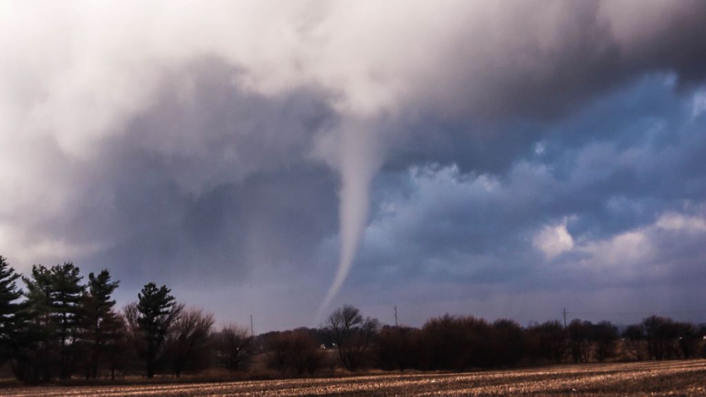
Instead, it was a warm and rainy February locally, with thunder being reported nearly as many times as it snowed. Taking it a step further, Mother Nature was so eager to skip right past winter that we had our first run-in with severe weather a little earlier than usual. On February 27th, the first tornadoes ever to be recorded in Champaign County during the month of February touched down — the first one west of Champaign, the second north of town along Interstate 57. Neither tornado caused damage, thankfully. Perhaps even more bizarre than the date the tornadoes occurred on, was the fact that the storms also moved through during the early morning hours with tornado warnings being issued for the area between roughly 8 a.m. and 10 a.m. that Monday morning.
Many have expressed out loud to me their deep concern that after a warm January and February we’ll be punished with a painfully cold March and April. As if to tease us with that fear, forecasts for the middle of March have trended colder in the Midwest.
Still, this appears to be a rather gentle dose of incoming cold. Perhaps it will feel a little exaggerated after such a stretch of mild weather, but there’s no early indication we’re looking at a late rally of air from the Arctic.
Could we see some March (or even April) snow? Oh yeah, absolutely. Many long-range prognosticators have suggested that the weather pattern will remain quite active across the Midwest through much of the spring months. With a recent adjustment to the jet stream bringing cold air a little closer our backyards, it’s certainly within reason that a couple of storm systems could bring enough cold air south to deliver some snow to the region just as we saw on Friday, March 3rd as a windy and rainy day turned into a windy and snowy evening.
You’ll probably hear many meteorologists hesitant to make any bold predictions for this spring as a whole, and that’s more than fair in 2023. We’re transitioning out of a long-lasting La Nina during a time of year that typically offers lots of chaos and very little certainty with respect to how exactly we’ll transition out of the winter season and eventually into summer across the Midwest and what bumps we’ll hit along the way.
As mentioned above, the core of March looks a little colder than average. Still, I’m probably skeptical at best that this is long-lasting cold. Warm air has proven to overachieve the past 6-8 weeks, and I’m curious to see if we don’t transition back to a warmer pattern by the end of the month. The next week or so looks active on the precipitation front, but there’s some evidence we may slow down a bit by mid-month as well, making this a bit of a tandem switch from warm and rainy to cold and dry over the next 10 to 20 days. From there, we’ll see!
All that being considered, if I had to make a call it would be for a March that finishes very near average for both temperatures and precipitation in Champaign-Urbana. From a temperature standpoint that would mean a lot of days with high temperatures in the 40s, and total precipitation of around 2.77”. Additionally, March averages 2.5” of snow in Champaign-Urbana.
Happy Spring!
Andrew operates Chambana Weather, where he publishes daily weather information for Champaign-Urbana and surrounding communities. He also serves as Senior Meteorologist with Nutrien Ag Solutions at Research Park, focused on domestic and international weather and its impact on agriculture.