


You know the old adage, “if you don’t like the weather in central Illinois, wait 5 minutes.” I’ve been stewing on that little phrase lately, because it just doesn’t seem to fit anymore. Something like “if you don’t like the weather in central Illinois, I’m sorry, this is what we’ve got for the next two weeks” might be a little more appropriate.
From February to April keeping the winter chill on full blast, to May having 31 out of 31 days warmer-than-average, to June soaking us with almost daily thunderstorms, it seems more and more that particular weather patterns are settling in and instead of paying us a quick visit, they’re locking in and hunkering down for weeks.
October was no different. The month came in hot, and then a chill settled in and refused to budge. The flip to a cooler pattern was advertised when I capped off my October preview in our September review — but determining when it is that these weather patterns are truly going to relinquish their grip has been frustrating, and not a challenge that’s been exclusive to our backyard.
Before we dive in any further, let’s look back at October as a whole. The month finished a little warmer than average, and a little drier than average. The mean temperature for October 2018 was 54.5 degrees, 0.6 degrees above average. Precipitation finishes at 2.29 thanks to a late push in the form of a rainy Halloween morning and night (sparing trick-or-treaters!) but still finishes 0.97″ shy of the monthly average of 3.26″.
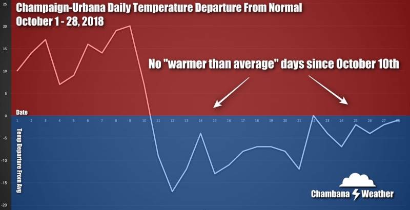
I mentioned above that October began with 10 straight warm days, but “hot” may be more fitting. An average October would typically feature daily high temperatures in the middle to upper 60s, but we were seeing high temperatures in the middle to upper 80s, with October 3rd and 8th nearly topping 90 degrees! Instead, it was our overnight low temperatures that were in the 60s.
Then, things flipped. From uninterrupted warmth to uninterrupted cold weather, we quickly plunged from the upper 80s to the 30s in just TWO days. Talk about weather whiplash! In fact, we experienced severe weather and temperatures in the upper 80s and snow with temperatures in the 30s during the same work week.
From October 11th to October 29th, every single day was colder than average aside from October 22nd, when we were exactly at our average temperature for the day.
Again, the October we know and love would feature afternoon high temperatures in the middle 60s, and we began with 80s and closed with 40s and 50s. We truly skipped fall. If you’re feeling like we got slighted, you’re not wrong.
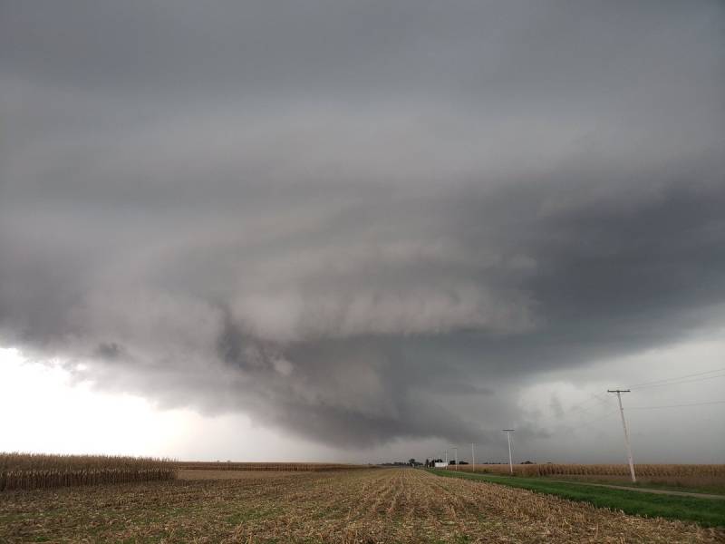
October precipitation was a little drier than expected, and the precipitation came fairly evenly spaced out through the month. The wettest day of the month was October 7th, when we saw 0.79″ fall in the Twin Cities. We also saw some severe weather on the 7th when a thunderstorm over Fisher prompted a Tornado Warning for part of Champaign County. Our first snowflakes fell on October 13th — the 3rd earliest we have ever seen snow in Champaign-Urbana.
So October finished cold, and it’s still cold, Andrew, what does the rest of November hold? I tell you what — the tone is being set for November, and it’s not a warm one. Not until late November, anyway.
The cold pattern that has settled in early this month only reinforces itself as we head into mid-November. Additionally, to reinforce the winter vibes I think we’ll see one or more chances for snow during the first half of November, perhaps some accumulating snow, and some *very* cold air for this time of year. When I’m recapping November for you in early December, I wouldn’t be shocked if I’m talking about days that were 20 to perhaps even 30 degrees colder than average.
When does the cold air loosen it’s grip? That’s the exact battle that meteorologists have been up against for what seems like this entire year. What feature in the global jet stream pattern that may or may not exist yet will be strong enough to kick this cold pattern out the door? As of this writing, the long-range weather models do toy with the idea of at least bringing us back to average for the last half of November, but I’d be lying if I said I was totally convinced this morning.
My best guess is that November finishes much colder than average. Even with some late month moderation, there’s nothing out there advertising we’ll see the kind of warmth needed to balance out the extreme cold of early to mid November.
Precipitation I think comes in at or just above average. The first half of November figures to be somewhat active in addition to the cold air. It is that active storm track with multiple storm systems dragging multiple cold fronts through our area that reinforces the cold weather pattern. Each of those cold fronts will typically bring with it the chance for precipitation.
I’ve said it before but I’ll mention it again — I’m talking about a very cold air weather pattern, but one that will be active with multiple chances for precipitation. Some of that precipitation is probably going to fall as snow. I won’t go naming dates and calling my shots for accumulation totals this far in advance, but my confidence is high that we’ll see more than one shot of snow this month.
So, from a cool late October into a bitterly cold November with a wintery vibe? If you don’t like it — you may be better off booking a vacation out of state than waiting for the next pattern change.
Photos and graphic by Andrew Pritchard