


Today’s mainstream weather continues to be all about the buzzwords, and it’s no secret by now that I loathe them all. Winter seems to bring out the absolute worst in the weather hype, from the naming of winter storms that began several years ago (be ready for Winter Storm Yolo this year… no, really), to click bait terms like “snowmageddon” and “snowpocalypse”, and the poor mis-understood polar vortex. So, what has the weather media salivating as we head into Winter 2015-2016? Godzilla El Niño.
Are you packing your bags and fleeing south yet?
What the hell does this mean? Is Godzilla El Niño the Abominable Snowman reincarnate coming to crush our beloved cities under his wintery wrath? Let’s just drop the Godzilla hype that the media has run with and just talk about it like adults.
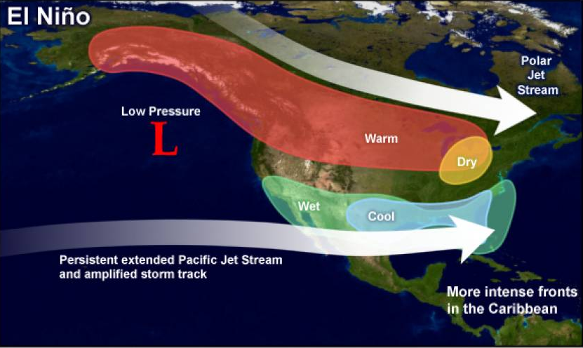
El Niño is the warm phase of the El Nino Southern Oscillation, with the cold phase La Niña being its counterpart. El Niño is characterized by a band of relatively warmer sea surface temperatures in the central and eastern equatorial regions of the Pacific Ocean off the coast of South America. The result of the warmer than average sea surface temperatures in an El Niño phase is a large area of high pressure in the western Pacific, and low pressure in the east. These regional pressure differences drive large fluctuations in the upper level jet stream that often leads to global changes in precipitation and temperature. El Niño is not a localized, mobile weather system (or giant Godzilla lizard) that “hits” or impacts a certain region. It is instead the instigating force that sets off a chain reaction of atmospheric events which could change your seasonal weather locally.
El Niño typically lasts for several months to two years at a time, and appears on an average of once in every five year period. However, a significant El Niño among the likes of which we are expected to see this winter has not been recorded since 1997-1998.
The influence of El Niño is drastically different from region to region. Naturally here in C-U we are most concerned with the impacts on the winter weather season here in the Midwest. The polar jet stream is often forced further north during the winter season with an El Niño phase present which keeps the frigid arctic air from invading as frequently, along with fewer storm systems impacting the region. So it follows that during a significant El Niño the effect on the Midwest would be above normal temperatures and below normal precipitation. This likely means less snow than your average Illinois winter, and perhaps, finally, a winter without the words “Polar Vortex” resurfacing (oops! Did I say that?). That said, none of this is a given. Is anything in weather, though? We have only limited data on El Niño/La Niña, and their impacts don’t always fall into line. A rogue snowstorm or cold snap could really skew the averages in a limited dataset.
Now none of you want to sit here and listen to me tell you that we don’t really know what this year’s El Niño will present to us this winter, so I’ll leave you with these general guidelines from years past. In six of the stronger El Niño’s occurring between 1957 and 1998 that were comparable to what we’re forecast to see this winter, central Illinois saw only 10-50% of their average snowfall, along with exceptionally warmer temperatures between 2°F and 6°F above average. That said, Mother Nature doesn’t like to follow the norm, nor does she like to give us what we’re expecting. As I mentioned above it would take just one rogue snowstorm to completely alter our perception of how the winter season went down. So keep your expectations in check, but I suppose I’d say, plan for a brown holiday season, but be OK with a white one too.