


October 2021 comes in as the 2nd wettest and 8th warmest on record (out of 129 years) in East-Central Illinois. This wasn’t a huge surprise and was perhaps a welcomed change compared to the past two cold Octobers — 2019 even featuring accumulating snow on Halloween!
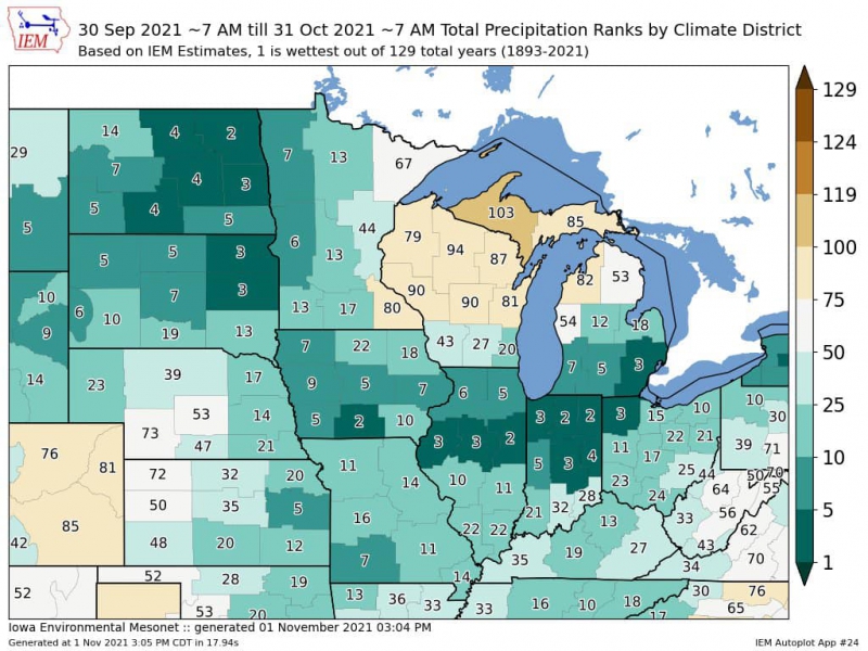
Image from Iowa Environmental Mesonet.
As we concluded September and looked ahead at the coming month, it was evident we would be on the warmer side of any incoming storm systems with a high confidence warm forecast. Precipitation was a bit more tricky. My call was for a near average October with respect to precipitation, but with the potential for a bust on the high side. What sent us to the extremely rainy side?
Through much of October a large trough (area of lower atmospheric pressure) over the Western U.S. was complimented by a large ridge (area of higher atmospheric pressure) in the east. The result was long-lasting warmth across the entire Midwest and Eastern U.S., colder temperatures in the Western U.S. and an active storm track between the two clashing air masses. Portions of the Midwest and Great Plains found themselves at ground zero for repeated rounds of rain and thunderstorms, sending everywhere from North Dakota to Ohio into a Top 10 wettest October on record. While I thought this pattern may eventually relent by late-month, it did not.
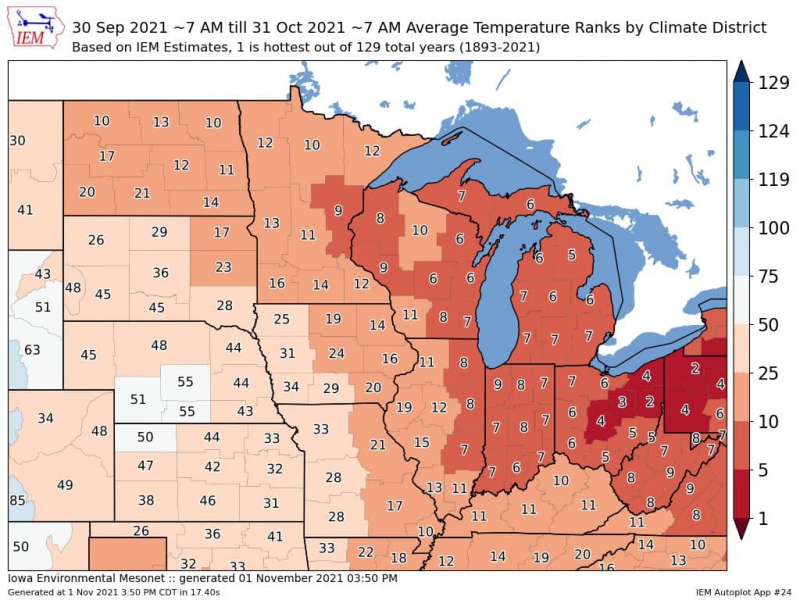
Image from Iowa Environmental Mesonet.
October 2021 comes in 5.6 degrees warmer than the monthly average of 60.5 degrees. Through the first half of October, that meant afternoon high temperatures in the 70s and 80s. A record high temperature of 87 degrees was set on October 11th, a day which also featured severe storms across Central Illinois. It wasn’t until October 16th that we saw a shot of cooler air with several days of crisp morning lows in the 40s and highs in the 60s. The last half of the month did feature more of a mixed bag of slightly warmer/slightly cooler than average temperatures, but the extreme warmth of the first two weeks kept the entire monthly average skewed warm enough to finish at 8th warmest all-time.
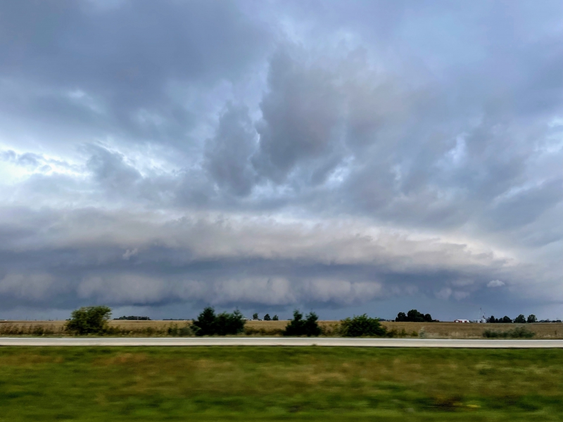
Photo by Andrew Pritchard.
It rained a lot in October. My leaky basement and exhausted sump pump are a testament to that. If it felt especially gloomy at times, you weren’t wrong. It rained on 19 of 31 possible days in October, with a mix of heavier rain and thunderstorms and dreary, drizzly days. Severe storms raced across Illinois on October 11th and 24th, though on both days previously tornadic storms mostly fizzled on the doorstep of Champaign-Urbana. The single rainiest day of the month was October was the 24-hour period spanning October 24-25 when nearly 3″ of rain was recorded as multiple rounds of noisy storms thundering their way across Champaign County from the early morning into the night.
The pattern finally relented as we flipped the calendar to November and we now find ourselves sitting in this dry, cold pattern with frosty mornings and crisp, sunny afternoons. Is this here to stay?
The easy answer is no. We’ll see change as soon as next week, with at least one storm system likely to bring us a few warmer, breezy days with rain and thunderstorms back in the forecast. The more complicated answer involves figuring out where we’re headed after that.
Early indications suggest that November is nowhere near the rainy month that October was, and it’s also not likely to flip back to long-lasting warmth. Right now, most long-range computer weather model guidance and tea leaf readings suggest that the last half of November continues to trend in a cooler direction, with precipitation near or a little below average.
While we are admittedly a bit cooler than average through the first few days of November, the record-setting warmth of last month has the chill feeling a bit more dramatic. For some this is a welcomed change, and for folks like my wife there simply are not enough blankets in the world.
For context, the monthly average temperature for November in Champaign-Urbana is 39.3 degrees, which typically means highs in the 40s and lows in the 20s/30s. We’ll touch the 60s for a couple of days next week, but I’d expect a lot of the above – daily low and high temperatures in the 20-45 degrees range over the last three weeks of November.
The average monthly precipitation total for November in C-U is 3.21″. This go around I think we finish on the drier side of the monthly average. We’ll see rain, and perhaps even our first snowflakes of the season, but I don’t anticipate nearly the ground-zero unrelenting rainy and stormy pattern of October. Instead, we’ll likely see a chance for precipitation every 5-7 days, with cooler, dry weather in between.
So, from a record warm and rainy October to a chilly, dry November? Plenty of dry days should at least provide nice weather for enjoying our late-season foliage!